
Why a Property Boundary Survey Matters Before Replacing an Old Fence
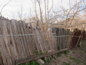
Replacing a fence feels straightforward. The old one is falling apart, you know roughly where your yard ends, and the new fence is going in the same spot. Simple enough. Except that old fence may have been wrong from day one, and rebuilding on top of a bad line means repeating someone else’s mistake at your own expense.
A property boundary survey before replacement is not optional caution. It’s the only way to confirm you’re building where you’re legally allowed to build.
How a Property Boundary Survey Confirms the True Location of Lot Lines
Old fences are not legal documents. They’re wood, chain link, or vinyl placed by someone years ago based on their best guess, a handshake agreement, or a marker they assumed was correct. None of that holds up when a neighbor challenges the line.
A property boundary survey goes back to the source: recorded plats, legal descriptions, and physical field measurements. A surveyor ties those records to actual ground coordinates. The result is a drawing that shows exactly where your lot ends, with documentation to back it up.
That’s different from eyeballing the old fence line. Very different.
Lot lines shift in perception over time. A fence installed two feet inside your neighbor’s property in 1991 has now “been there forever.” The neighbor’s landscaping has grown around it. Everyone assumes it’s the line. A survey cuts through all of that and shows what the recorded documents actually say.
In areas with older housing stock and frequent ownership turnover, this gap between physical fences and legal boundaries comes up often. Don’t assume the fence that’s been there for 20 years is in the right place.
Common Boundary Issues Revealed by a Property Boundary Survey
A survey doesn’t just confirm what you hope is true. Sometimes it turns up problems that were sitting there quietly, waiting for someone to notice.
Encroachments from neighboring structures. A shed, driveway, or old fence from the adjacent lot may be sitting on your property. You won’t know until the corners are located and measured.
Missing or disturbed property markers. Iron pins get removed during construction or landscaping. Concrete monuments deteriorate. When physical markers are gone, there’s no reliable reference for where the line runs without a new survey.
Gaps between recorded descriptions and field conditions. Sometimes the legal description in the deed doesn’t perfectly match what’s on the ground. These discrepancies have to be resolved before a fence gets placed, or the problem gets worse.
Boundary line agreements that weren’t recorded. Two previous owners may have agreed to adjust a shared line without filing paperwork. That agreement may not be binding on current owners, and a new survey will expose the discrepancy.
Any of these issues is easier to address before construction than after.
Why Replacing an Existing Fence Without a Property Boundary Survey Can Create Problems
Most fence replacement disputes don’t start with bad intentions. They start with an assumption.
The homeowner assumes the old fence was right. The contractor builds the new fence on the same line. The neighbor notices it’s two feet into their yard. Now there’s a dispute over a brand-new fence that has to be relocated or litigated.
Replacing without a survey also creates permit problems. Many municipalities require a site plan that shows the fence location relative to the legal property lines. If your plan is based on a fence line that turns out to be wrong, the permit application has incorrect data. That can delay approval or trigger a correction request.
There’s a cost angle here too. Removing and relocating a fence that was just installed costs more than doing the survey upfront. The survey is a fraction of that expense.
Some homeowners argue the fence has been there for decades, so it must be correct. That logic doesn’t hold. Long-standing fences that sit on the wrong line have been relocated after surveys, even when both neighbors thought the line was settled. Time does not make a wrong boundary right.
Easements and Setback Requirements a Property Boundary Survey Can Identify
A fence can be on the correct property line and still be illegal to build.
Utility easements run along the rear and sides of many residential lots. These are strips of land where utility companies have the legal right to access and work. A fence inside an easement area can be ordered removed, regardless of where the property line falls.
Setback rules add another layer. Local zoning codes set minimum distances between a fence and the street, the property line, or existing structures. These vary by fence height, yard location and zoning district.
A boundary survey shows the property lines. It doesn’t automatically pull zoning data, but it gives the surveyor and the homeowner a clear drawing to work from when checking setback compliance. Pair the survey with a zoning review from the local building department before the project starts.
The combination of easement locations and accurate lot lines tells you the actual buildable zone for the fence. That’s the information a permit application requires.
How a Property Boundary Survey Helps Prevent Neighbor Disputes
Neighbor disputes over fences are common in South Florida. A survey won’t stop a difficult neighbor from being difficult. But it gives you documented, professionally produced evidence of where the boundary sits.
When both parties can see a signed and sealed survey drawing that shows the lot lines based on recorded documents and field measurements, most disagreements end there. The line is not a matter of opinion anymore.
That documentation also travels with the property. Future buyers, title companies and attorneys will have access to the survey record. A clean boundary history is worth more than most homeowners realize when it’s time to sell.
Disputes that do escalate to legal action are far easier to resolve when a current survey exists. Courts and mediators work from documented evidence. A survey is exactly that.
One more angle: proactive communication with a neighbor before replacing a fence, backed by a survey drawing, tends to prevent disputes from starting at all. Showing someone a professionally produced document is a different conversation than arguing about where you think the line is.
Frequently Asked Questions
Does replacing an existing fence require a new survey?
Many municipalities require a site plan showing the fence location relative to the property lines as part of the permit application. If you don’t have a recent survey, you’ll likely need one before the permit is approved.
What if the old fence has been in place for many years?
Age doesn’t confirm accuracy. A fence that has stood for decades can still be in the wrong location. A current boundary survey is the only way to verify the line based on legal records.
Can a property boundary survey reveal that my neighbor’s fence is on my land?
Yes. If a neighboring fence, shed or driveway crosses your legal boundary, the survey will show it. Addressing that before you build your replacement fence is much cleaner than dealing with it after.
How does a survey account for utility easements?
Easements recorded in the title documents should appear on the survey drawing. Your surveyor can flag those areas so you know where placement restrictions apply.
What’s the difference between a boundary survey and a survey sketch from a home purchase?
A survey sketch prepared for closing is often a limited product, used for title insurance purposes only. A full boundary survey involves physical fieldwork to locate and confirm the actual corners and is the appropriate product for fence permitting.
For a free land surveying quote, call us at (305) 912-7795 or send us a message by going here.
Posted in land surveying, land surveyor |