
How Drainage Paths Can Affect Lot Planning
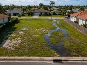
A lot that looks buildable on a map can become a problem the moment rain hits it. Water pooling in the wrong spot, runoff crossing a neighbor’s property and hidden drainage easements can all force a site plan to change after design work has already been paid for. A topo survey done before lot planning begins shows exactly how water moves across a site. In Hialeah, where flat land and heavy summer rain create real drainage problems, that information separates a plan that works from one that has to be redone.
Why Water Movement Determines What Gets Built Where
Water follows the lowest path. On a flat lot, that path isn’t always easy to see. A few inches of height difference can determine whether water drains away from a building or collects against it.
Most lots in Hialeah sit at low elevations with very little slope. That makes drainage harder. Water has fewer places to go. When a building, driveway or parking area covers the ground, water that used to spread out now builds up. That water has to go somewhere. If the lot plan didn’t account for it, it usually ends up causing damage or code problems.
A topo survey maps the elevation across the whole site. It shows the high spots, the low spots and where water naturally flows. That survey data is the starting point for any lot plan that needs to handle stormwater correctly.
Four Ways Drainage Paths Change Lot Planning Decisions
Where the Building Can Safely Sit
The lowest parts of a lot are usually the worst spots for a building. Water collects there. In flood-prone areas, finished floor heights must meet minimum rules set by FEMA and local codes.
In Miami-Dade County, finished floor rules apply to new construction in mapped flood zones. A lot plan that puts a building in a low drainage area may need a lot of fill to raise the floor to code. That fill adds cost and changes the grading of the whole site.
A topo survey finds those low spots before the building is placed. The designer can then put the structure on higher ground or plan the fill needed to meet the rules, rather than finding the problem after the site plan is done.
Recorded and Unrecorded Drainage Restrictions
Many lots in Hialeah have recorded drainage easements. These are strips of land set aside for stormwater flow or drainage pipes. Buildings, fences and most paved areas can’t go inside those easements.
A topo survey combined with a review of the plat and title documents shows where those easements are. If a drainage easement cuts through the planned building area, the lot plan has to change. Finding that conflict before design starts saves time and money.
Natural drainage paths that aren’t formally recorded can also limit where things go. A swale that has carried water across a property for years may be treated as a drainage feature that can’t be blocked under local stormwater rules. The topo survey finds those features so the designer knows what has to stay.
Post-Development Runoff and County Stormwater Rules
Miami-Dade County requires stormwater plans for new development. Those plans must show that the developed site doesn’t send more runoff onto nearby properties or into drainage systems than it did before.
That calculation starts with knowing how the site currently drains. The topo survey gives the engineer the existing conditions data needed to model pre-development drainage. Without that baseline, the stormwater plan is built on estimates that may not match the real site.
When the topo survey shows a site drains toward a neighboring property or a sensitive drainage outlet, the lot plan has to include detention, retention or flow redirection. Knowing that early means those features can be built into the layout from the start.
Paved Surface Grading and Storm System Connections
Paved surfaces change how water moves. A parking lot or driveway that sends water toward a building, a neighbor’s property or a public road creates both a drainage problem and a code issue.
The topo survey shows existing grades that affect where paved areas can drain. A parking area on a natural high spot can be graded to drain toward an outlet. A parking area in a low spot will collect water unless the lot plan includes inlets and storm system connections.
In Hialeah, connecting to the municipal storm system requires coordination with Miami-Dade County. The topo survey gives the engineer the data needed to design a connection that meets county standards.
The Real Cost of Skipping Drainage Data at the Start
Designing without drainage data creates the same problems over and over.
Buildings end up in flood-prone areas and need expensive fill or foundation changes later. Stormwater from the new site runs onto neighboring properties and creates disputes. Drainage easements show up during permit review and force a redesign. Stormwater plans get rejected because they’re based on assumed conditions that don’t match the real site.
Every one of those problems costs more to fix than a topo survey would have cost at the start.
Frequently Asked Questions
What is a topo survey and why does it matter for lot planning?
A topo survey maps the elevations and physical features of a site in detail. It identifies high points, low areas, slopes, and natural drainage patterns. This information helps designers determine building locations, grading needs, and how stormwater will move across the property after development.
How do drainage easements affect lot planning?
Drainage easements are designated areas reserved for stormwater flow, drainage infrastructure, or maintenance access. Buildings and many site improvements cannot be placed within these areas. A topo survey combined with a title and plat review helps identify drainage easements early, reducing the risk of design conflicts and permit delays.
Is a stormwater management plan required for new development projects?
Many development projects require a stormwater management plan to demonstrate that post-development runoff will be properly controlled. Preparing this analysis typically depends on accurate existing-site data collected through a topo survey, which establishes the baseline conditions needed for design and regulatory review.
Can drainage patterns affect where a building is placed on a lot?
Yes. Low-lying areas and natural drainage paths can create flooding and water management challenges if buildings are placed there. A topo survey identifies these conditions early so designers can position structures in more suitable locations and minimize grading and fill requirements.
What problems can occur when drainage data is not considered during lot planning?
Without accurate topo survey data, development plans may place structures in flood-prone areas, create drainage issues for neighboring properties, or rely on incorrect stormwater calculations. These problems often result in redesign costs, permit delays, and construction challenges that could have been avoided during the planning stage.For a free land surveying quote, call us at (305) 912-7795 or send us a message by going here.