
Land Surveying Around New Paths, Crossings, and Bike Facilities
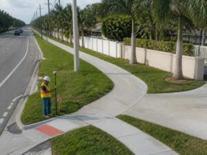
A new shared-use path can look simple on a plan and turn messy in the field. The route crosses driveways, dips at a road, and skims property lines nobody mapped. Land surveying is what keeps that path on the right ground, at the right grade, and inside the right boundaries. Skip it and you get crossings that don’t line up and improvements that spill onto a neighbor’s lot. For developers, an early survey saves redesign, permit delays, and change orders once crews are on site. This guide walks through where surveying fits, how it guides the route, elevations at crossings, boundary limits, and turning survey points into field layout.
Where Land Surveying Fits Into Path and Bike Facility Planning
Surveying comes first, before the path is designed, because the design can only be as good as the site data behind it. The surveyor maps what’s already on the ground. That means the shape of the land, the existing features, the boundaries, and the utilities that a new route has to respect.
The main deliverable is an existing conditions survey, often paired with a topographic survey. It shows spot elevations, contours, pavement edges, drainage structures, poles, and trees. Planners use that base map to test where a path can go and how it will sit in the space. The surveyor also sets control points, which are fixed reference marks the whole project measures from. Without that groundwork, the design floats on guesses, and guesses turn into field problems that cost money to fix.
Timing matters as much as the data. Bring the surveyor in during early planning, not after a layout is half drawn. An early survey lets the designer test two or three route options against real ground before picking one. That saves the redraw work that happens when a path is designed on a bad assumption and has to move later.
Route Alignment Around Streets, Driveways, and Other Features
Survey data pins down where every driveway, road edge, tree, and structure actually sits, so the route can thread between them instead of through them. A plan sheet might show a clean strip of open ground. The real site often has a mailbox, a power pole, and a storm inlet right in the way.
Locating those features is the surveyor’s job. Curb lines, access points, sign posts, and mature trees all get measured and placed on the map. That lets the designer keep the path clear of driveways and hold the spacing the route needs. It also flags conflicts early, like a pole that has to be relocated or a tree worth saving. When the alignment is drawn over real positions instead of assumptions, the path fits the site the first time and needs fewer revisions during permitting.
Sight lines belong on the list too. A path that crosses a driveway or a side street needs clear views so a rider and a driver can see each other in time. The survey shows where fences, walls, and shrubs sit, which helps the designer spot a blind corner before it becomes a safety complaint. Fixing a sight-line problem on paper is far cheaper than moving a wall after the path opens.
Elevation Changes at Crossings and Path Connections
Surveyed elevations show the small grade changes where a path meets a road, sidewalk, or trail, and those spots are where a design lives or dies. A crossing that looks flat on paper can hide a two-inch lip that stops a wheelchair or catches a bike tire. Only measured elevations catch that before it’s poured.
The surveyor takes spot shots at each connection point. Those points show how the path ties into a curb ramp, a gutter, or an existing sidewalk. Public routes have to meet accessibility limits, such as a cross-slope at or under 2 percent and running slopes within set ranges, so the survey data has to be tight enough to design against. Drainage rides on these same elevations, since a path that traps water becomes a slick or icy hazard at the crossing. Smooth transitions keep water from ponding at the joint and keep the crossing usable for everyone. Getting the elevations right here prevents the kind of rework that shows up only after the concrete cures.
Property Lines and Right-of-Way Limits Along New Routes
A boundary and right-of-way survey shows exactly where public land ends and private land begins, so the path stays where it’s allowed to be. New paths often run inside a road right-of-way or a dedicated easement. The corridor is only as wide as the record says, and building past that line creates a real problem.
The survey clarifies that usable width along the whole route. It marks the boundaries, the right-of-way limits, and any easements the path has to share. That tells the team where improvements can sit and where an extra easement might be needed from an adjacent owner. Catching a tight spot early means the design can shift a few feet or the developer can start the easement process on time. Skip this step and a finished path can end up encroaching, which can force removal or a costly after-the-fact agreement.
Recorded documents drive this work. The surveyor pulls deeds, plats, and easement records, then ties them to what’s marked on the ground. Sometimes the record and the field evidence disagree, and that gap has to be settled before design gets far. A clear picture of the corridor up front keeps the whole project out of boundary fights later.
From Survey Points to Construction Layout in the Field
Once the route is designed, the surveyor stakes it out so crews build the real path exactly where the plan put it. The design is a set of points and elevations. Field layout turns those numbers into marks on the ground that the crew can follow.
The surveyor sets the centerline and offset stakes so the path holds its shape and width. Grade stakes show the crew how high to build at each point, which matters most at crossings and ramps where slope has to stay in range. Key locations get marked too, like the edges of a crossing, the base of a curb ramp, and any structure the path connects to. As the work moves along, checks against the control points keep everything true to the design. A final as-built survey then confirms the path was built as planned, which helps close out permits and hand the project over clean.
For a free land surveying quote, call us at (305) 912-7795 or send us a message by going here.
Posted in land surveying, land surveyor | Tagged Land Surveying