
Property Survey Problems That Can Stay Hidden for Decades
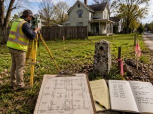
A property can sit quiet for fifty years and still hide a survey problem. The deed looks clean. The fence has stood forever. Then you order a property survey before building, and the lines do not match the records. Old mistakes do not fix themselves. They wait. For developers buying older parcels, a buried boundary issue can stall the whole project. It can also shrink the land you can build on. Here is how these problems hide for decades, and how to catch them before they cost you.
How Decades of Ownership Changes Affect Property Records
Every time a property sells, paperwork piles up. The county records a new deed. Sometimes a clerk copies the description wrong. Over decades, small copy errors stack on top of each other. One sale describes the lot one way. The next sale tweaks a number or drops a call. By the fifth or sixth owner, the written record may not match the ground at all. Splits make it worse. When an owner carves off a piece to sell, the math has to add up. It often does not. You end up with strips of land that belong to no one on paper. Or to two owners at once. A current survey pulls the chain of deeds and finds where the record drifted.
When Original Survey Evidence Has Disappeared
Surveyors mark corners with physical markers. Iron pins, concrete posts, sometimes just an old stone or a nail. These survey markers are the proof of where a line really sits. The problem is they do not last. Pins rust away. Construction crews rip them out. Roads and parking lots bury them. Some markers from old surveys are simply gone. When the original evidence disappears, a surveyor has to rebuild the boundary from clues. They search old plats, deed calls and any markers still left nearby. They look for fences and tree lines that match the old descriptions.
It is detective work. Two good surveyors can even read the same thin evidence a little differently. That is how a line ends up in question fifty years later.
Why Older Subdivisions Can Present Unique Survey Challenges
Surveyors laid out old subdivisions with simple tools. They used steel chains and magnetic compasses. Both drift. A chain stretches and wears with use. A compass reading shifts as magnetic north moves over the years. So the bearings written in 1950 do not point exactly where they would today. Old plats also used loose descriptions. A line might run to a big oak that died decades ago, or along a fence that someone later moved. Stack a whole subdivision of these lots together and the small errors add up across the block. One lot can come up a foot short. The next can overlap its neighbor. Build on the wrong assumption and you put a wall on land you do not own.
How Modern Measurements Compare With Historic Records
Modern surveys are far more precise. A surveyor today uses GPS gear and total stations that measure to a fraction of an inch. The old chain-and-compass work was good for its time, but it cannot match that. So when a modern crew resurveys an old lot, the new numbers rarely line up perfectly with the historic record. That gap is normal. A small difference does not mean anyone made a mistake. The job is to reconcile the two. A good surveyor honors what the old deed meant. Then they use modern tools to mark it. They do not just trust the new GPS reading and toss out a hundred years of records. They tie the two together. That keeps a fresh survey accurate and legal.
Resolving Longstanding Property Questions Before They Become Disputes
You can fix an old boundary question. The trick is to do it before a neighbor or a permit office forces the issue. Start with a current survey from a licensed surveyor. They research the records and recover what evidence still sits on the ground. Once you know where the real problem is, you have options:
- A boundary line agreement, where both owners sign off on an agreed line
- A corrective deed that fixes a bad description in the record
- A quiet title action, handled by an attorney, when the question needs a court
- An updated recorded plat that brings the paperwork in line with the survey
Sort this out early and it stays a paperwork task. Wait until you are mid-build, and it turns into a stop-work order and a fight. A clean record also makes the property easier to sell or finance later. Buyers and lenders do not like surprises in the chain of title.
Frequently Asked Questions
What is a property survey?
A property survey is a measured map of a parcel’s boundaries and features. A licensed surveyor researches the deed records, recovers corner markers and confirms where the lines fall. The result shows the legal limits of the land and any conflicts with the record.
Why do old property records not match the land?
Records drift over time. Clerks copy descriptions wrong. Owners split parcels with bad math. The old tools were less precise. Decades of these small errors stack up. A modern survey often finds gaps between what the paper says and where the lines really sit.
Can a property survey problem affect my ability to build?
Yes. A hidden boundary issue can shrink your buildable area or block a permit. If a structure crosses a line, the city may halt the work. Catching the problem before design lets you adjust the plan instead of tearing out finished work.
What happens if my survey does not match my neighbor’s?
Two surveys can disagree when the old evidence is thin. The surveyors compare their research and the markers each one found. Often they reach a shared answer. If they cannot, the owners can sign a boundary line agreement or take the question to court.
How far back does a surveyor research property records?
A surveyor traces the chain of title as far back as the records go. Sometimes that reaches the first plat or land grant. They follow each deed and split to see how the description changed. That history shows where and when the boundary record first went wrong.