Why A Topographic Survey Matters Before Redevelopment
Hialeah is changing fast. Old homes are getting upgrades. Small lots are turning into bigger projects. Some owners add space. Others tear down and rebuild.
That sounds simple, but many projects hit problems early.
Most of those problems come from one issue: the land does not match the plan.
A property may look flat. It may look easy to build on. But once work starts, the real shape of the land shows up. That is where delays begin.
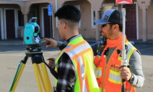
In Hialeah, many projects now start with a topographic survey before any design takes place.
Why Many Redevelopment Projects Start With Wrong Assumptions
Many property owners move straight into design. They hire a contractor. They draw a plan. They think the site is ready.
But land is rarely perfect.
Small slopes exist even when you cannot see them. Water may flow in a direction that surprises you. Past owners may have changed the ground without records.
So the design ends up based on guesses.
At first, everything looks fine. Then the plan meets reality.
What Goes Wrong During Redevelopment
This is where things start to get expensive.
A driveway might end up too high or too low. Water can collect near the house. In some cases, the yard drains toward a neighbor instead of the street.
None of this shows up on paper. It shows up during construction.
Then the changes begin.
Crews stop work. Plans get adjusted. Costs rise. Timelines stretch.
Some owners even deal with problems after the job is done. Water runoff becomes an issue. Neighbors raise concerns. Inspectors may ask for fixes.
In many cases, these problems start early, when there is no clear understanding of the land before work begins. That is where a topographic survey before redeveloping your property makes a real difference.
Why This Happens More
Hialeah has its own challenges.
Lots are often tight. Space is limited. Many homes in Hialeah have been around for decades. Over time, people add patios, driveways, sheds, or extensions.
Not all of those changes follow a clear plan. Some affect how water moves across the property. Others change the ground level in small ways.
Now redevelopment adds pressure.
Owners want to build bigger or use the land in new ways. But the site still carries all those past changes.
So when new plans come in, they clash with existing conditions.
That is where mistakes happen.
How a Topographic Survey Helps Before You Build
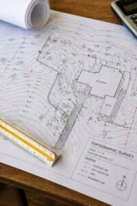 A topographic survey shows the real shape of the land.
It maps elevation across the property. It shows high and low points. It shows how water flows.
It also captures existing features like driveways, slabs, and surface changes.
With that information, the design fits the site.
Engineers can adjust grading early. Drainage plans can follow the natural slope. Builders know what to expect before work starts.
That leads to smoother progress.
No guessing. No surprises.
Better Plans Mean Faster Approvals
Permits often slow down projects.
Plans go to the city for review. Reviewers check if everything meets local rules. If something looks off, they send it back.
Then revisions begin.
A topographic survey helps avoid that loop.
Plans based on real site data make sense right away. Drainage paths look correct. Elevations line up. Layout fits the property.
That reduces back-and-forth.
It also helps keep the project moving.
What It Costs to Skip This Step
Skipping a topographic survey may seem like a way to save money.
It rarely works out that way.
Design errors cost more to fix later. Construction delays add labor costs. Material changes increase the budget.
Even small grading fixes can add up fast.
In some cases, owners must redo parts of the project. That hurts both time and money.
A survey done early avoids those problems.
When You Should Get a Topographic Survey
Timing matters.
The best time is before design starts.
That gives engineers and contractors the right data from the beginning. It also helps you make better decisions about what is possible on your lot.
It becomes even more important if the property looks uneven, has older improvements, is being expanded, or has had drainage issues before.
Waiting too long puts the project at risk.
Why It Matters for Real Projects, Not Just Plans
This is not just about drawings.
It affects how the finished property performs.
A well-planned site drains properly. It avoids water damage. It reduces stress on structures.
It also helps prevent conflicts with neighbors.
That matters in places like Hialeah, where properties sit close together.
Good site planning starts with accurate data.
Start With the Land, Not the Guess
Redevelopment brings opportunity. It can increase value. It can improve how a property works.
But it also brings risk.
Many of those risks come from not knowing the land well enough at the start.
A topographic survey removes that guesswork.
It gives a clear picture of what is really there. It helps plans match the site. It keeps projects on track.
If you plan to redevelop property in Hialeah, starting with accurate site data can help you avoid delays and costly changes later.
Posted inland surveying, land surveyor | Tagged: flood survey