How to Read an As-Built Survey
You just received your as-built survey. It is full of lines, numbers, symbols, and notes that can feel impossible to understand at first. Meanwhile, your permit may be on hold, your contractor keeps asking questions, or your closing date is getting closer.
If you own property, you will likely deal with an as-built survey at some point. The good news is that once you understand the basics, the document becomes much easier to read.
What Is an As-Built Survey?
An as-built survey shows the actual completed condition of a property after construction. It includes structures, setbacks, elevations, and improvements exactly as they exist in real life. Property owners use these surveys during permitting, inspections, closings, and construction reviews.
Think of it this way: building plans show what was supposed to be built. An as-built survey shows what was actually built after the work was finished.
It is different from a boundary survey, which mainly shows property lines. It is also different from a topographic survey, which maps the shape and elevation of the land. An as-built survey combines several details into one document.
The survey usually includes:
- Property boundaries
- Structures and additions
- Driveways and walkways
- Setback measurements
- Elevation information
- Easements
- FEMA flood zone data
This matters because construction does not always match the approved plans exactly. Small differences can create permit problems, inspection delays, or legal issues later.
Why Are As-Built Surveys Important?
Hialeah requires updated certified surveys for many permit applications, including additions, sheds, pools, awnings, concrete work, and demolitions. If a survey does not meet city or county standards, the project may face delays during review or inspection.
Many property owners are surprised by how strict the local rules are.
Hialeah and Miami-Dade County both review permit documents carefully. In many cases, an older survey will not be accepted, even if the property has not changed much. The city often requires a recent survey signed and sealed by a licensed surveyor.
If the survey is incomplete or outdated, several things can happen:
- Final inspections may get delayed
- Certificates of Occupancy may be placed on hold
- Closings and refinancing can slow down
- Contractors may not receive final payments on time
That is why reviewing the survey carefully before submission is important.
How to Read an As-Built Survey Step by Step
Reading an as-built survey involves reviewing the property identification, surveyor certification, site plan drawing, setbacks, elevations, FEMA flood information, and all visible improvements on the property. Each section helps confirm whether the property meets local building requirements.
Let’s go through the document section by section.
Section 1: Property Identification
The top section of the survey identifies the property being measured.
You will usually see:
- Property address
- Folio number
- Legal description
- Lot and block number
- Subdivision name
- Plat book reference
- Survey date
The folio number is Miami-Dade County’s unique property identification number. The legal description must match county records exactly.
Even a small mistake can create problems during permitting or closing.
Also pay attention to the survey date. Hialeah may reject surveys that are considered outdated.
Section 2: Surveyor Seal and Certification
The surveyor certification section is one of the most important parts of the entire document.
This section includes:
- Surveyor’s name
- Florida license number
- Signature
- Official seal
- Certification statement
The seal confirms that the survey was completed by a licensed land surveyor who personally verified the measurements in the field.
Without the seal and signature, the survey has no legal value for permitting purposes.
According to the Florida Board of Professional Surveyors and Mappers, surveys used in Florida must be signed and sealed by a properly licensed professional.
One important thing to remember is that the surveyor only certifies visible and measurable conditions. The survey does not confirm underground utilities, structural strength, or hidden defects.
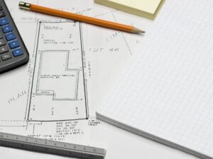
Section 3: Site Plan Drawing and Symbols
The site plan drawing is the main visual section of the survey. At first, it may look confusing, but most surveys use common symbols and line styles.
Common Symbols on an As-Built Survey
- Solid bold lines → Property boundaries
- Dashed lines → Easements or utility areas
- Thin solid lines → Buildings, patios, driveways, and improvements
- North arrow → Property orientation
- Scale bar → Real-world distance reference
- Setback dimensions → Distance from structures to property lines
- FFE label → Finished Floor Elevation
Every structure should include measurements showing how far it sits from the property boundaries.
These measurements are called setbacks.
Setbacks matter because Hialeah zoning rules limit how close structures can sit to property lines. If a structure is too close, the property may have a setback violation.
That can delay permits, inspections, or future property sales.
Section 4: Finished Floor Elevation (FFE)
Finished Floor Elevation, often labeled FFE, shows the height of the building’s finished floor above sea level.
In flood-prone areas like Hialeah and Miami-Dade County, this number is extremely important.
Lenders and insurance companies compare the FFE to FEMA’s Base Flood Elevation (BFE) for the area.
If the building sits below the BFE:
- Flood insurance costs may increase
- Additional flood protection may be required
- Permit approvals may take longer
Even a small elevation difference can affect insurance premiums significantly.
If the FFE listed on the survey does not match the Elevation Certificate, contact your surveyor immediately to review the discrepancy.
Section 5: FEMA Flood Zone Information
Your as-built survey should also show the FEMA flood zone designation for the property.
In Hialeah, common flood zones include:
- AE Zone → High flood risk with established base flood elevations
- X Zone → Lower flood risk area
The survey should also include:
- FEMA map number
- Flood panel number
- Effective map date
Missing or outdated FEMA information can create problems during refinancing, permitting, or closing.
According to FEMA, Miami-Dade County contains many properties located within Special Flood Hazard Areas that require elevation review during permitting and insurance evaluations.
Before submitting the survey, verify that the flood information is current and accurate.
Section 6: Structures, Improvements, and Hidden Red Flags
Every visible improvement on the property should appear on the as-built survey.
This includes:
- Houses
- Additions
- Sheds
- Pools
- Patios
- Fences
- Driveways
- Decks
- AC equipment pads
- Walkways
This section often reveals hidden problems.
For example, a previous owner may have enclosed a garage or added a shed without permits. Once those improvements appear on the survey, the building department can see them as well.
An as-built survey can reveal:
- Setback violations
- Unpermitted additions
- Easement conflicts
- Encroachments
- Elevation discrepancies
Finding these issues early is much better than discovering them during a sale or inspection.
In many cases, property owners can still correct the issue through updated permits or property modifications.
What Should You Do if Something Looks Wrong on the Survey?
If an as-built survey reveals a possible problem, property owners should contact a licensed surveyor first. Surveyors can explain measurements, review compliance concerns, and help determine whether corrections or permits may be needed.
Do not panic if something looks incorrect.
Survey issues are more common than many people realize, and most problems have solutions.
Start by speaking with the surveyor who prepared the document. They can explain:
- Whether the issue is serious
- If corrections are needed
- Whether additional permits may be required
- If the survey needs updating
For larger problems, you may also need help from:
- Permit expediters
- Contractors
- Zoning consultants
- Real estate attorneys
The important thing is catching the issue early before it delays a project or closing.
Frequently Asked Questions
How long is an as-built survey valid?
Hialeah often requires recent certified surveys for permitting. Older surveys may be rejected if they do not reflect current property conditions.
Can an old survey be reused for a permit?
Sometimes, but many projects require updated surveys signed by a licensed surveyor.
Does an as-built survey show flood risk?
Yes. Most as-built surveys include FEMA flood zone information and Finished Floor Elevation details.
Can unpermitted structures appear on an as-built survey?
Yes. Sheds, additions, enclosed garages, and other visible improvements typically appear on the survey whether they were permitted or not.
For a free land surveying quote, call us at (305) 912-7795 or send us a message by going here.
Posted in land surveying, land surveyor |